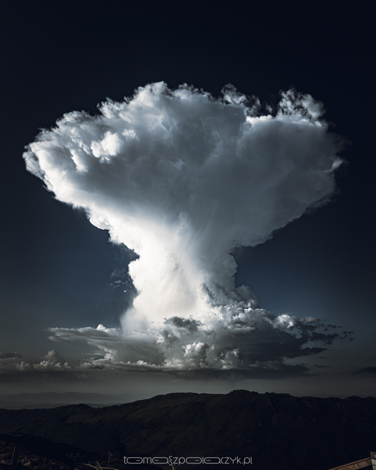
We have a stormy season (although, for now, quite meager), so as a reminder, here's an interesting fact captured once on the Polish-Ukrainian border.
In the photo, we can see a sizable specimen of a Cumulonimbus capillatus cloud - although the word "sizable" doesn't accurately convey the enormity of this cloud, you'll have to take my word for it that it occupied a space in the sky from the horizon up to about 70 degrees above - I've never seen anything larger in my life 🙂. Unfortunately, the photograph is unable to capture the view and actually compresses the scale.
Putting the photo aside, let's return to our protagonist: Visible above is the anvil-shaped part of the thundercloud, known as the incus (mushroom), with clearly feathery/fibrous top portions of the cloud. Below, on the "stem," you can discern the outlines of rain streaks, which represent atmospheric precipitation that may not necessarily reach the ground (due to very strong updrafts of up to 25 m/s), but I believe that was the case here. The base of this type of cloud is located at an altitude of approximately 2-3 km, while its upper limit can reach up to 20 km. The cloud consists of water droplets in the lower part and ice crystals in the upper part. These clouds have the most vertical development, which is why the physical phenomena occurring within them are very violent.
Bieszczady Mountain,Tarnica, June 2021 - view towards NNE.
___________________________________________________
Mamy sezon burzowy (chociaż, póki co, dość ubogi) więc dla przypomnienia, taka oto ciekawostka ustrzelona kiedyś nad granicą polsko-ukraińską.
Na zdjęciu pokaźnych rozmiarów okaz chmury typu Cumulonimbus capillatus - chociaż słowo "pokaźnych" niebyt trafnie oddaje ogrom tej chmury, ale musicie uwierzyć na słowo, że zajmowała na niebie przestrzeń od horyzontu po jakieś 70 stopni w górę - w życiu nie widziałem nic większego 🙂. Niestety, fotografia nie jest w stanie oddać tego widoku, a wręcz kompresuje skalę.
Mniejsza z fotografią, wróćmy do naszego bohatera:
widoczne kowadło chmury burzowej tzw. incus (grzyb), z wyraźnie pierzastymi/włóknistymi częściami szczytowymi chmury. Poniżej na "nóżce" dostrzegalny zarys smug opadowych, czyli opadu atmosferycznego który niekoniecznie (ze względu na bardzo silne prądy wznoszące - do 25m/s) może sięgać gruntu i chyba w tym przypadku tak właśnie było.
Podstawa chmury tego rodzaju, to wysokość ok 2–3 km, natomiast górny jej pułap może wznosić się nawet na 20 km. Chmura złożona w dolnej części z kropel wody, a w górnej z kryształków lodu, są to chmury najbardziej rozbudowane w kierunku pionowym, dlatego zjawiska fizyczne w nich występujące są bardzo gwałtowne.
Bieszczady, Tarnica, czerwiec 2021r. - widok w kierunku NNE.